Is India Growing? India’s Coastline Just Got 48% Longer—Here’s Why! From 7,516 km to 11,098 km: How Better Mapping Changed the Numbers, Not the Geography
When news broke that India’s coastline had increased from 7,516 kilometers to a whopping 11,098 kilometers—a jump of nearly 48%—many people raised eyebrows. Was this a result of land reclamation, territorial expansion, or perhaps some tectonic shift? Not quite. The real story behind this dramatic rise in the length of India’s coastline is less about physical changes to the land and more about technological advancement and refined calculation methods.
This change tells us more about how we measure than about what’s being measured.
Understanding the Change: From 7,516 km to 11,098 km
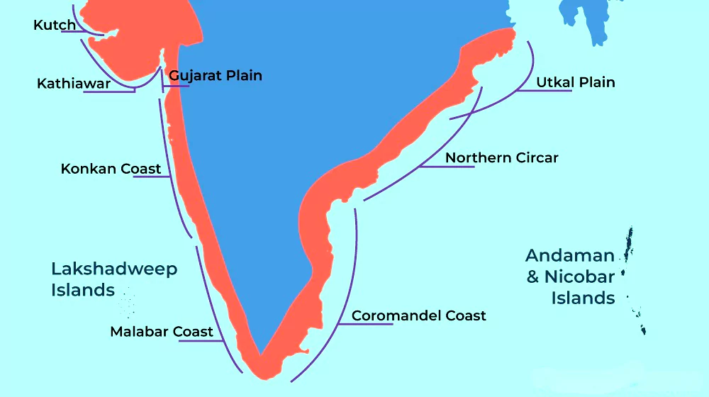
For years, India’s coastline was officially recorded as 7,516 km long, covering the stretch along the mainland and the shorelines of the Andaman & Nicobar and Lakshadweep Islands. This number remained constant in geography textbooks, government documents, and academic reports for decades.
But recent recalculations—driven by improved satellite imagery, high-resolution digital mapping, and the inclusion of smaller offshore islands and intricate coastal features—have significantly revised this figure. The new measurement stands at 11,098 km, indicating a 3,582 km increase in coastal length.
Let’s be clear: India hasn’t physically gained new land along the seas. Instead, our tools for measurement have gotten sharper and more precise.
Why the Coastline Appears Longer Now
There are a few major reasons behind the updated figure:
1. Improved Satellite Imagery
Modern satellites provide far better resolution than ever before. With images detailed to a few meters or even centimeters, it’s now possible to trace coastlines more accurately—including every inlet, sandbar, creek, and curve that may have been previously overlooked.
2. Inclusion of Smaller Offshore Islands
Previously, many tiny islands, sandbanks, and rock outcrops were not included in the official coastline calculation. These features, while small, add up when counted together. With more islands now being factored in—especially in remote areas like the Andaman Sea—the total length increases naturally.
3. Change in Methodology
Earlier calculations may have used broader strokes, ignoring minor undulations or features in favor of a smoother, generalized line. Now, authorities follow more intricate mapping practices, often using what’s called the “high-resolution coastline delineation” technique. This method captures minute changes and complexities along the coast, giving a much longer measurement.
The “Coastline Paradox”
This sudden jump also brings to light a fascinating mathematical concept known as the “coastline paradox.” Simply put, the more closely you try to measure a coastline, the longer it becomes. That’s because coastlines are full of nooks, bays, and irregularities. The more detailed your measuring tool, the more of these features you capture—and the longer the total measurement becomes.
So, a straight-line ruler might give you one figure, but a flexible tape measure that goes into every tiny inlet and bend will produce a much larger one. The paradox reminds us that geographic measurement isn’t always straightforward—it depends heavily on the scale and precision used.
What This Means for India
Though the physical landmass hasn’t expanded, this change in coastline length has real implications:
1. Coastal Management
A longer coastline means more responsibility. From erosion control to marine conservation and disaster preparedness (especially in cyclone-prone regions), the government now has to plan for a much broader area.
2. Maritime Boundaries
While internal recalculations don’t change international boundaries, they can affect how we plan our Exclusive Economic Zone (EEZ) and maritime security. A more detailed coastal map improves our understanding of the area over which India has sovereign rights for exploring marine resources.
3. Fisheries and Livelihoods
With a clearer picture of the coastal terrain, more areas could potentially be opened up for sustainable fishing, aquaculture, and related industries. This could directly benefit thousands of coastal communities.
4. Environmental Impact Assessment
Any development—ports, harbors, industrial corridors—requires a clear understanding of ecological boundaries. A more accurate coastline map ensures better environmental planning and fewer conflicts with conservation efforts.
Looking Ahead: Mapping for the Future
The recalculated coastline isn’t just a number—it’s a reflection of India’s growing technological capabilities. The use of GIS (Geographic Information Systems), remote sensing, and drone-based surveying is transforming how we understand our geography. With climate change causing sea-level rise and shifting coastal dynamics, constant updates and re-mapping are becoming more important than ever.
Moreover, such data-driven precision plays a critical role in national planning. Whether it’s designing coastal roads, predicting flood zones, or building blue economy strategies, having the right numbers makes all the difference.
Final Thoughts: It’s the Measurement That Changed, Not the Land
The increase from 7,516 km to 11,098 km doesn’t reflect any sudden geographic miracle or expansion of territory. Instead, it’s a testament to how far we’ve come in mapping technology and data accuracy. By taking into account every small detail—every bay, spit, and sandbank—India has arrived at a more realistic and informed picture of its coastline.
In a world where data drives decisions, this revised coastline is more than just a cartographic update—it’s a foundation for smarter governance, sustainable development, and coastal resilience.
The New Oil? 10 Facts About Why Rare Earth Minerals Are Fueling Global Tensions | Maya


