National Waterways in India: Unlocking the Power of Inland Water Transport- India, blessed with a vast network of rivers, canals, backwaters, and creeks, has immense potential for inland water transport (IWT). Yet for decades, this mode of transportation remained underutilized. To harness its full potential, the Government of India declared several stretches of navigable rivers and waterways as National Waterways.
Today, National Waterways represent a key part of India’s sustainable transport vision—offering an economical, fuel-efficient, and eco-friendly alternative to road and rail.
What Are National Waterways?
National Waterways are inland water bodies (rivers, canals, backwaters, etc.) designated by the central government as important for navigation and transport. These waterways are governed by the Inland Waterways Authority of India (IWAI), which is responsible for their development and regulation.
National Waterways are intended to promote cargo movement, passenger services, tourism, and connectivity between rural and urban centers across states.
Historical Background
-
The idea of developing National Waterways emerged in the 1980s.
-
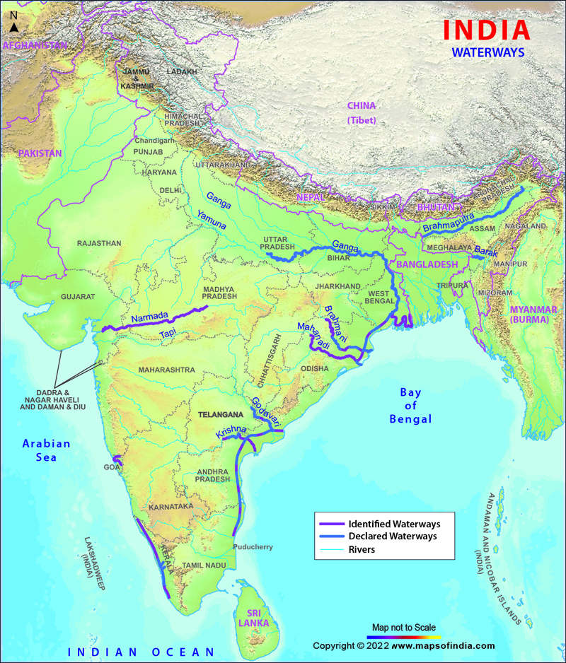
National Waterway 1 (NW-1), the Allahabad–Haldia stretch of the Ganga-Bhagirathi-Hooghly river system, was declared the first National Waterway in 1986.
-
Until 2016, only five waterways had National Waterway status.
-
In 2016, the government passed the National Waterways Act, which added 106 new waterways, taking the total number to 111 National Waterways.
This expansion marked a turning point in India’s transportation infrastructure planning, signaling a shift toward utilizing natural river systems for commerce and mobility.
Major National Waterways
Below are some key National Waterways that form the backbone of India’s inland water transport:
1. National Waterway 1 (NW-1)
-
Stretch: Allahabad (Prayagraj) to Haldia via Varanasi, Patna, Bhagalpur, and Kolkata
-
Length: 1,620 km
-
River System: Ganga–Bhagirathi–Hooghly
-
Importance: One of the longest and most commercially significant waterways. It supports cargo movement, cruise tourism, and passenger transport.
-
Project: Jal Marg Vikas Project is enhancing infrastructure along NW-1.
2. National Waterway 2 (NW-2)
-
Stretch: Dhubri to Sadiya in Assam
-
Length: 891 km
-
River: Brahmaputra
-
Significance: Crucial for connectivity in the Northeast, especially for Assam and Arunachal Pradesh.
3. National Waterway 3 (NW-3)
-
Stretch: Kollam to Kottapuram in Kerala
-
Length: 205 km
-
Route: West Coast Canal along with the Champakkara and Udyogmandal canals
-
Highlight: The only waterway with regular cargo and passenger ferry services. It connects the major backwaters of Kerala.
4. National Waterway 4 (NW-4)
-
Stretch: Kakinada–Puducherry
-
Length: 1,078 km
-
Rivers/Crosses: Godavari, Krishna, and Buckingham Canal
-
Potential: Major route for transporting goods across Andhra Pradesh and Tamil Nadu.
5. National Waterway 5 (NW-5)
-
Stretch: Talcher to Dhamra via Paradip
-
Length: 623 km
-
Rivers: Brahmani, Kharsua, and Mahanadi Delta
-
Purpose: Designed for coal and industrial cargo transport in Odisha.
Benefits of National Waterways
-
Low Cost of Transportation: IWT is 60–70% cheaper than road and rail for bulk goods.
-
Fuel Efficient and Environment-Friendly: Water transport consumes less fuel and emits less CO₂.
-
Decongests Roads and Railways: Helps reduce traffic and logistical pressure on other transport networks.
-
Boost to Trade and Industry: Enhances connectivity to ports and hinterlands.
-
Employment and Tourism: Creates new jobs in shipping, logistics, and eco-tourism.
Challenges in Implementation
Despite its potential, the development of National Waterways in India faces several hurdles:
-
Seasonal Flow Variation: Many rivers are not navigable year-round due to dry seasons or flooding.
-
Depth Maintenance: Dredging is often required to maintain minimum navigable depth, which is costly and environmentally sensitive.
-
Encroachments and Pollution: Riverbanks and water bodies face pollution, illegal settlements, and siltation.
-
Limited Infrastructure: Many stretches lack terminals, jetties, and navigation aids.
-
Integration Issues: Coordination with road, rail, and port systems remains a challenge.
Recent Developments
-
The Jal Marg Vikas Project, launched by the Ministry of Shipping, aims to develop NW-1 with multimodal terminals, navigation aids, and dredging.
-
Inland water terminals have been inaugurated in Varanasi, Sahibganj, and Haldia.
-
Trial runs for cargo movement have successfully taken place on various stretches including Ganga, Brahmaputra, and even in Goa and Kerala.
-
Ro-Ro (Roll-on/Roll-off) ferry services have been launched in several states to enhance passenger transport and reduce fuel use.
A Future Built on Rivers
With rapid urbanization, congested roads, and rising fuel prices, India’s return to its riverine roots offers a timely and sustainable transport solution. The National Waterways network, though still developing, has the potential to revolutionize trade, tourism, and public transport across the country.
Continued investments in infrastructure, smart integration with road–rail networks, and community participation will be essential to unlock the full potential of this silent, steady, and green transport revolution.


