The Geography of Climate in America: Understanding Its Unique Impact on Weather and Environment
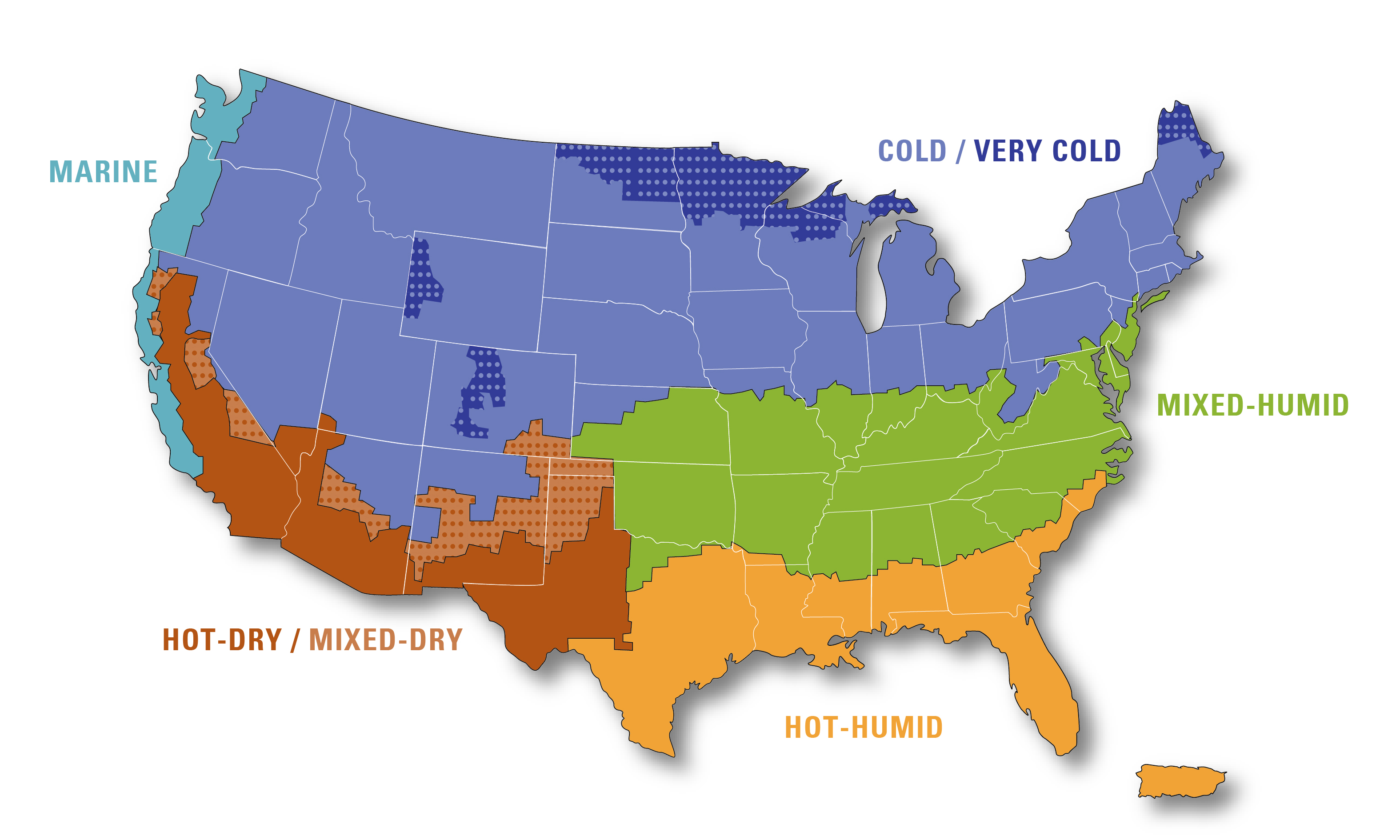
The geography of climate in America is as diverse as the country itself, with climates ranging from the frigid temperatures of Alaska to the warm, tropical breezes of Florida. In Alaska, for example, average winter temperatures can drop to around -20°F (-29°C) in some areas, while summer temperatures in coastal cities like Anchorage hover around 60°F (15°C). Meanwhile, Florida’s tropical climate sees average temperatures around 70°F to 90°F (21°C to 32°C) year-round, with higher humidity. The United States’ vast geography, from the mountains to the oceans, creates a striking variety of climate zones, each with unique weather patterns that shape the environment, human activity, and economy.
2024 has already broken the record set by 2023, becoming the hottest year on record, with temperatures so extreme that one scientist called them “gobsmackingly bananas”.
Experts predict this year will surpass 2023, with the global average temperature possibly hitting 1.5°C (2.7°F) above pre-industrial levels. This threshold was agreed upon internationally to avoid more intense storms, floods, and heatwaves.
With the growing threat of climate change, understanding how geography impacts these climates is more important than ever, as it helps us navigate the challenges of an unpredictable future..
The Diverse Climate Zones in America
The United States is home to a wide range of climate zones, influenced by geographical features like mountains, oceans, and altitude. Let’s explore how these factors shape climates across the country.
1. Coastal and Oceanic Influence: East and West Coasts
The U.S. coasts are deeply affected by surrounding oceans, which moderate the climate. On the Pacific Coast, places like San Francisco experience mild, Mediterranean-like conditions with average temperatures around 50°F to 65°F (10°C to 18°C) throughout the year. Moving southward, Southern California, including Los Angeles, sees warmer temperatures averaging 60°F to 75°F (16°C to 24°C). On the Atlantic Coast, the Gulf Stream warms regions like Florida, leading to a humid subtropical climate with average temperatures ranging from 60°F (16°C) in winter to 90°F (32°C) in summer.
2. Mountain Ranges and Elevation: The Rockies and Sierra Nevada
The Rocky Mountains and Sierra Nevada create significant temperature differences based on altitude. At higher elevations, like in Denver, temperatures can average 40°F (4°C) in winter and 70°F (21°C) in summer, while areas at lower elevations can be much warmer. The moisture-blocking effect of these mountains also creates drier conditions to the west, such as the desert-like regions of Nevada, where summer temperatures can soar above 100°F (38°C).
3. The Great Plains and Tornado Alley
Known as Tornado Alley, this central U.S. region experiences extreme temperature variations, with summers averaging 85°F to 100°F (29°C to 38°C), and winters ranging from 20°F to 40°F (-6°C to 4°C). This range, combined with minimal natural barriers, makes the area prone to severe thunderstorms and tornadoes.
4. Alaska and the Arctic Climate
Alaska’s climate is split between the extreme cold of the Arctic in the north, where winter temperatures can plunge to -40°F (-40°C), and milder conditions in coastal areas like Juneau, which experiences average temperatures from 20°F (-6°C) in winter to 60°F (16°C) in summer.
The Growing Impact of Climate Change on America’s Geography
While America’s climate has always been shaped by geography, the growing influence of climate change is increasingly disrupting weather patterns and environmental stability across the country.
1. Rising Sea Levels and Coastal Flooding
Coastal areas, especially along the East and Gulf Coasts, are at risk of rising sea levels, with cities like Miami seeing average sea level rise of around 8-10 inches over the past century. This poses a growing threat of flooding and erosion, impacting infrastructure and ecosystems.
2. Increasing Wildfires in the West
The West Coast, including states like California, is seeing more intense wildfires, driven by hotter temperatures and prolonged droughts. For instance, California’s average annual temperature has risen by 2°F (1.1°C) over the past few decades, contributing to longer and more destructive fire seasons.
3. More Intense Hurricanes
Warmer ocean temperatures are fueling more powerful hurricanes. In 2022, Hurricane Ian brought devastating winds up to 150 mph (241 km/h) to Florida. As sea temperatures rise, these storms are expected to increase in intensity, threatening coastal communities.
4. Drought and Water Scarcity in the Southwest
The Southwest U.S., including areas like Arizona and Nevada, is facing worsening drought conditions, with average precipitation levels dropping and temperatures rising. This has led to reduced water supplies from vital sources like the Colorado River, threatening agriculture and water access.
5. Shifts in Agricultural Zones
Rising temperatures are shifting agricultural zones. While the Northern Great Plains are seeing longer growing seasons, the Southwest is becoming less suitable for water-intensive crops like cotton. These changes can disrupt farming practices and food production across the country.
The Green Revolution Miracle That Saved Lives—and Left a Devastating Environmental Price | Maya
Final Words: The Future of America’s Climate Geography
The geography of climate in America is constantly evolving due to both natural forces and human-induced climate change. From coastlines to mountains, the country’s diverse landscapes are facing more unpredictable and extreme weather events. Understanding how geography shapes climate, and how climate change is altering this balance, is essential for preparing for a more uncertain future. As the impact of climate change grows, the way we interact with and protect our environments will be more crucial than ever.


